NiBRAS Research
[1] Satellite-based Framework for Modeling Reservoir Operation
This study presents the water management value of a modeling framework to predict the current and future reservoir operating rules
in lower Nile basin using satellite earth observations and hydrologic models.
The platform comprises the Variable Infiltration Capacity (VIC) hydrologic model driven by high spatial and temporal resolution of satellite observations.
Reservoir storage change is estimated using altimeter and visible imagery of lake area for Lake Nasser and then applied
to infer reservoir operation for High Aswan Dam (HAD).

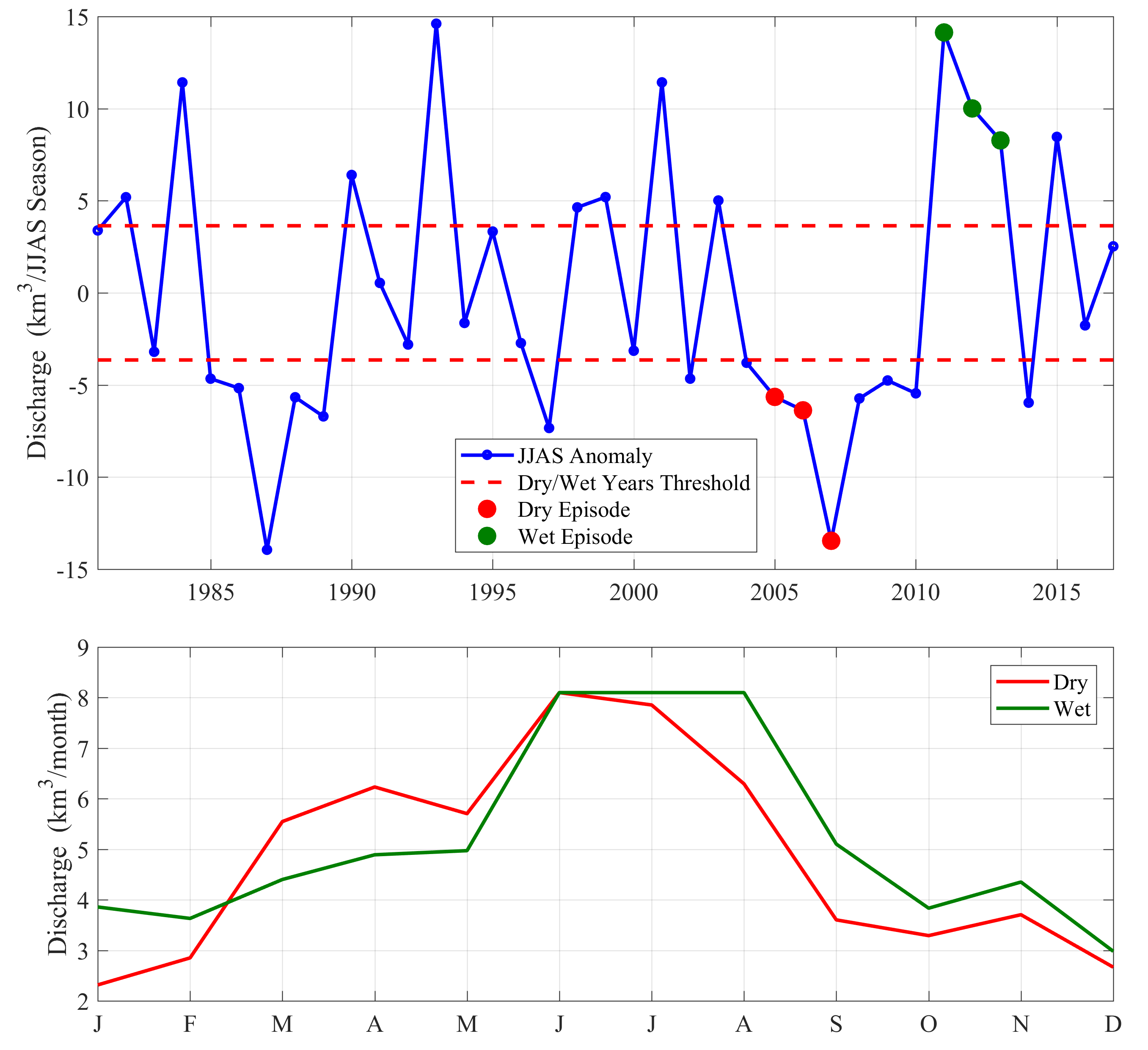
Upper Panel: The discharge anomalies at Eldiem station (location of GERD dam in Ethiopia) averaged over the rainy season JJAS (June-July-August-September) during the period (1981–2017). Lower Panel: Operating curve of HAD for wet vs drought episodes using the satellite-based framework
Highlights
• The hydrological modeling of the BNB shows high accuracy in simulating streamflow along the Blue Nile Basin (validated at Khartoum and Eldiem stations).
• Monthly HAD releases using satellite altimeter show good agreement with measured discharge downstream of the dam.
Reference: Eldardiry, H., & Hossain, F. (2019). Understanding Reservoir Operating Rules in the Transboundary Nile River Basin Using Macroscale Hydrologic Modeling with Satellite Measurements. Journal of Hydrometeorology, 20(11), 2253-2269 (DOI: https://doi.org/10.1175/JHM-D-19-0058.1).
[2] Adapting High Aswan Dam Operation to Challenges of the Grand Ethiopian Renaissance Dam
The adaptation of HAD operation to GERD construction typifies one of the challenges facing dam operators and water managers in downstream Nile riparian countries.
Recently, various studies have investigated the impacts of GERD on downstream countries with more focus on the GERD filling strategies.
However, crucial insights on how dam operators can adapt to potential impacts have not been capitalized in previous studies.
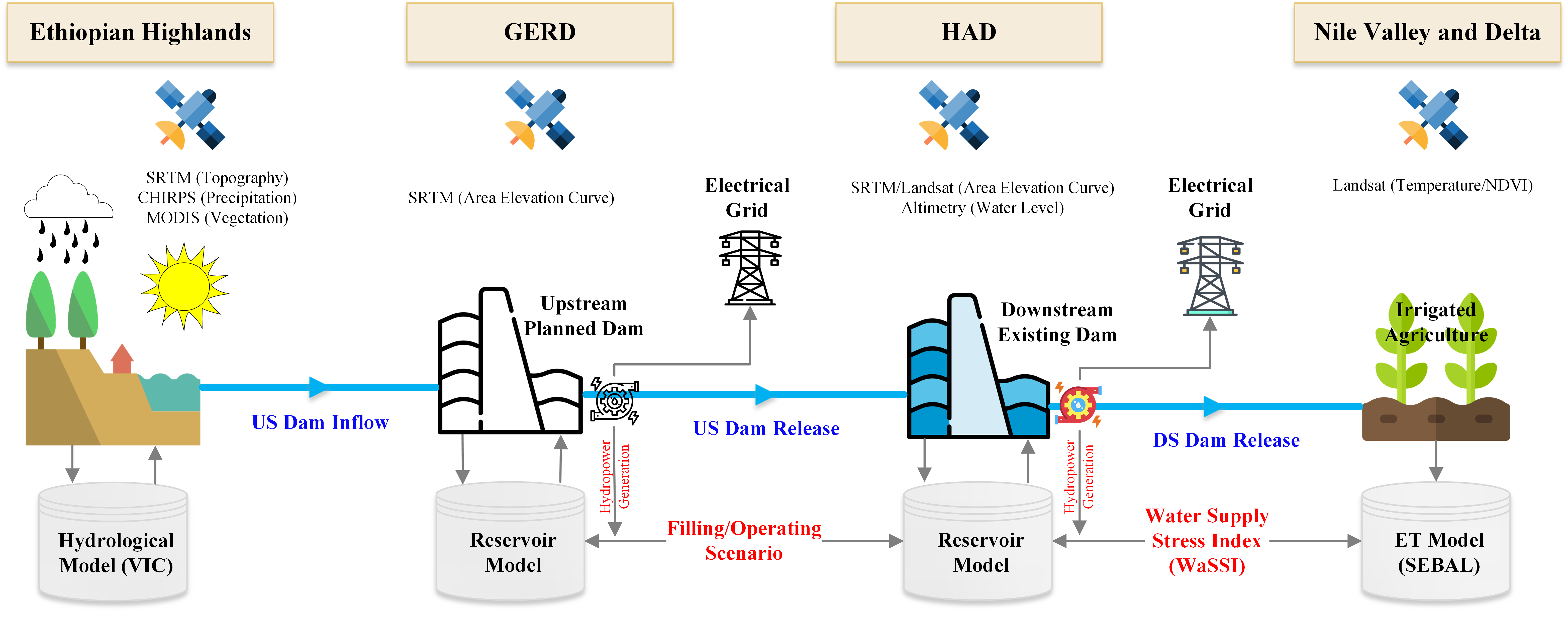
Our study proposes a physical blueprint that employs water scarcity indices to infer modified reservoir operation
that could adapt to streamflow alterations while maintaining the supply to downstream water use, i.e., water supply for irrigation and hydropower demands.

Schematic diagram of the blueprint proposed to re-evaluate the operation of existing dam under the filling/operation of an upstream planned dam.
Highlights
• High Aswan Dam can adapt its operation in summer months by elevating the downstream stress level (store more and release less),
to mitigate the effects of rapid GERD filling.
• A 7-year filling scenario by Ethiopia is minimally disruptive to operations of High Aswan Dam and results in faster recovery.
Reference:
Eldardiry, H., & Hossain, F. (2020). A Blueprint for Adapting High Aswan Dam Operation in Egypt to Challenges of Filling
and Operation of the Grand Ethiopian Renaissance Dam. Journal of Hydrology (DOI: https://doi.org/10.1016/j.jhydrol.2020.125708).
[3] Evaluating the Hydropower Capacity of Grand Ethiopian Renaissance Dam
One of the largest hydropower projects in Africa is the Grand Ethiopian Renaissance Dam (GERD), which is currently under construction in
the Upper Blue Nile (UBN) basin in Ethiopia.
The GERD has been billed as a hydropower project that will significantly improve electricity supply in Ethiopia and neighboring countries with a total capacity of 6450 MW.
This study evaluates the hydrological potential of the UBN basin for meeting the declared hydropower production design from the GERD.
The assessment of GERD hydropower generation was based on using a dynamic programming approach to optimize the reservoir operation
under a combination of different configurations including 1) the installed capacity (current design vs lower capacity); 2) the capacity factor;
3) minimum operating level; 4) full supply level; and 5) yearly electricity demand curve.

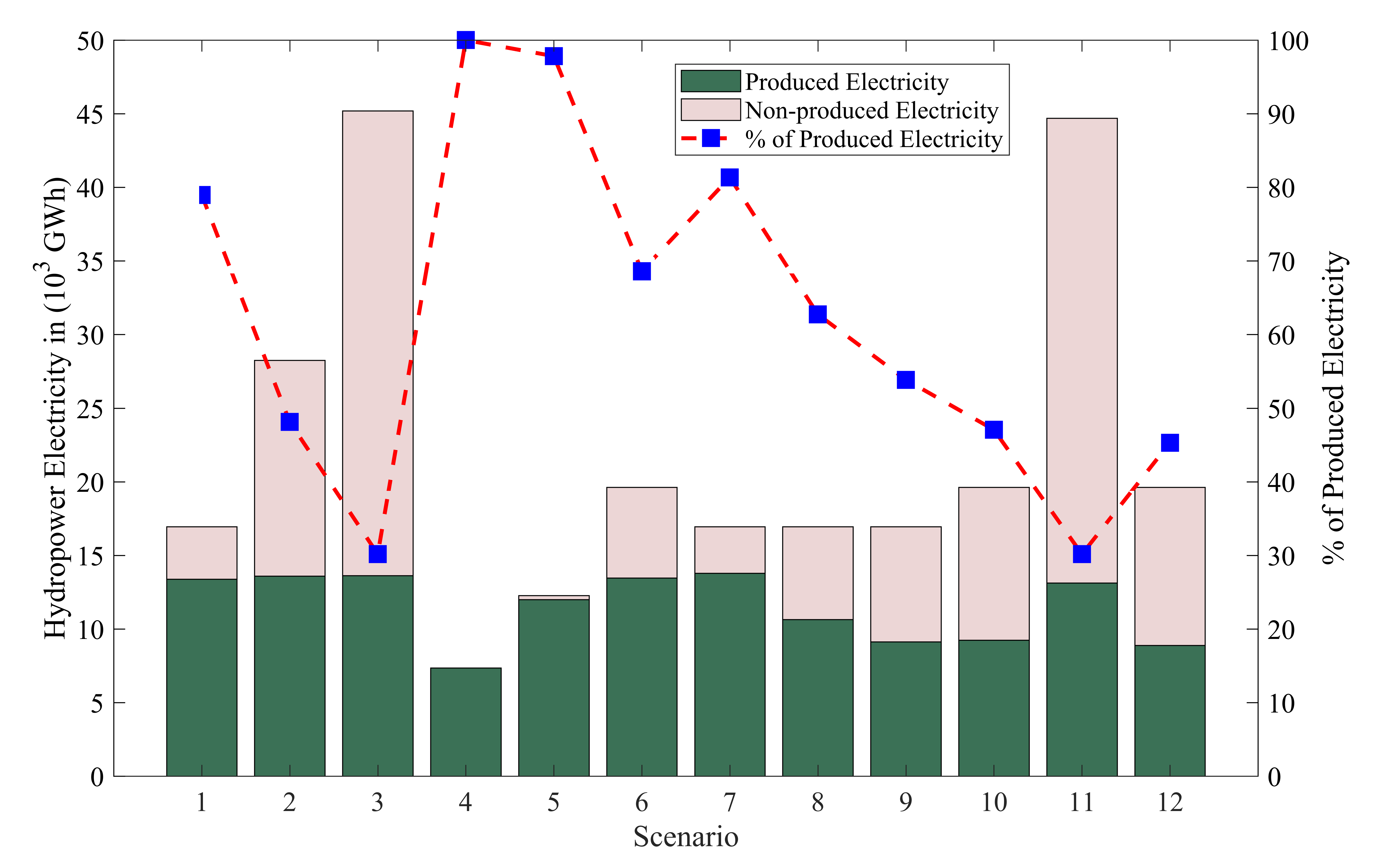
Annual produced (and non-produced) electricity (GWh) for different assessment scenarios (Refer to Table 1 in the paper for the configuration of each assessment scenario).
Highlights
• The hydrology of the Upper Blue Nile does not sustain the inflow to GERD that would be required to meet the officially declared goal of
generating more than 16000 GWh per annum.
• The current installed capacity (6450 MW) would result in about nine idle turbines (out of 16 installed turbines) throughout the year.
• A lower capacity of 2800 MW is found to be a more reasonable design that is supported by the hydrology with no loss in hydropower production.
Reference: Eldardiry, H., & Hossain, F. (2021). Can Grand Ethiopian Renaissance Dam Live up to its Promise of Hydropower? Journal of Renewable and Sustainable Energy.
[4] The Value of Long-term Streamflow Forecasts in Adaptive Reservoir Operation
Our study evaluates the use of long-term climate forecasts
to improve real-time operations of High Aswan Dam (HAD) in the Nile river basin.
A suite of eight models from North American Multimodel Ensemble (NMME) are used to generate monthly precipitation
and temperature forecasts at up to 12 months of lead time. The NMME forcing are used to drive the Variable Infiltration Capacity (VIC) model
and produce monthly streamflow forecasts for an optimization horizon of four years from 1998 to 2001.
The value of NMME-based forecasts to reservoir operations are compared with perfect and climatology-based forecasts.

Forecast-based Adaptive Reservoir Operation (FARO) framework for deriving adaptive reservoir operating policy using streamflow forecasts
Highlights
• The forecast horizon for HAD operation ranges between 8- and 11-month lead time at low and high demand scenarios, respectively, beyond which the forecast information no longer improves the release decision.
• Actual forecasts from NMME models can significantly improve the HAD operation with an average gain in forecast value of 77%
compared to the climatology-based forecasts.
• When considering the operation of upstream Grand Ethiopian Renaissance Dam (GERD), using streamflow forecasts minimally helps to maintain current target objectives of HAD operation and therefore result in higher operation costs as opposed to current conditions without GERD.
Reference: Eldardiry, H., & Hossain, F. (2021). The Value of Long-term Streamflow Forecasts in Adaptive Reservoir Operation: The Case of High Aswan Dam in the Transboundary Nile River Basin. Journal of Hydrometeorology.
[5] Informing Decisions on Reservoir Operation Using Satellite Remote Sensing
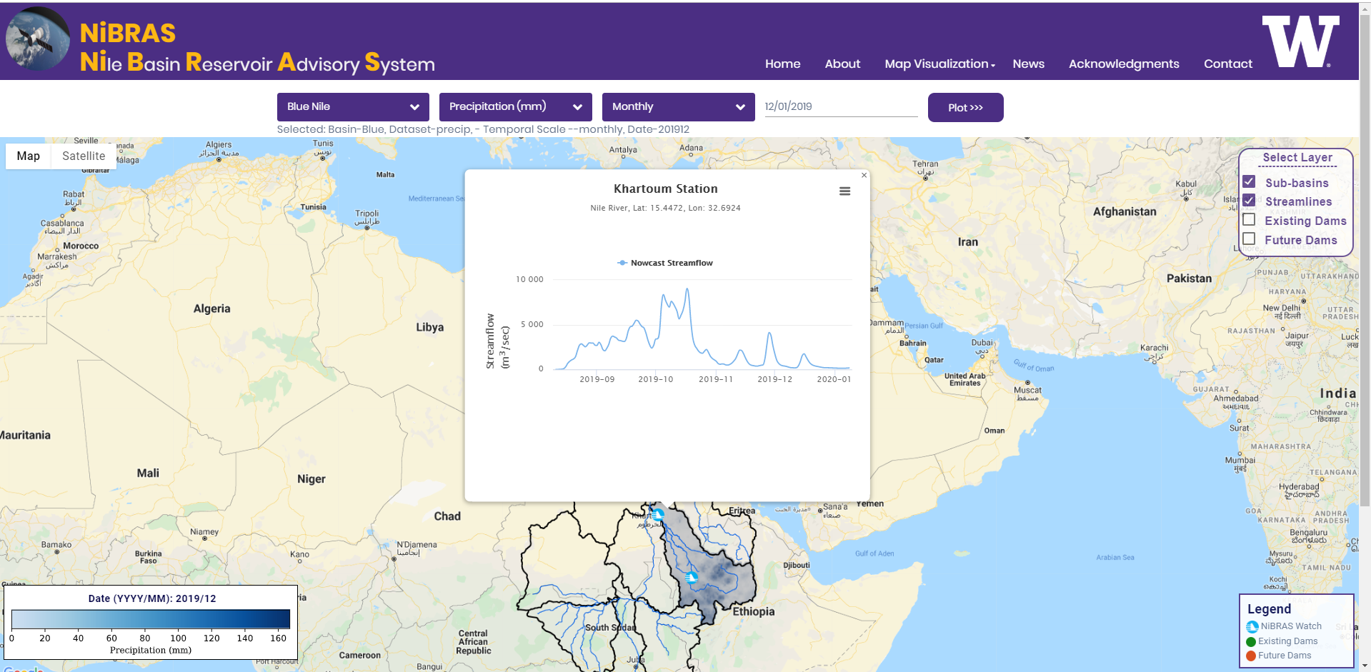
NiBRAS (Nile Basin River Advisory System; means “light” in Arabic) is a web-based operational system that aims to advance societal impacts by converting the results from the scientific research into sound decision support system. NiBRAS integrates complex back-end models with front-end user needs. The system benefits from the growth of open-source and non-proprietary tools, e.g., Google Earth Engine API, which made it possible to build a cost-effective real-time operational system. NiBRAS will assist water managers and dam operators to make more informed decisions by assessing various operational procedures and their impacts interactively.

An example of the current front-end of the NiBRAS system providing a real-time monitoring of Blue Nile hydrology.
Highlights
• The NiBRAS system will promote
the societal applications of various water-related satellite/forecast products in the Nile basin
• The system functionality facilitates the understanding of the water management issues associated with reservoir operation in the Nile basin
and provides a basis for evaluating potential solutions.
• NiBRAS Provides a tangible tool forward to facilitate the negotiations for new dam plans
Reference:
Eldardiry, H., & Hossain, F. (In prep). Nile Basin Reservoir Advisory System: A Satellite-based Framework
to inform Decisions on Reservoir Operations in the Transboundary Nile River Basin (Environmental Modeling and Software).